All posts by Noel Churchill

The thing I loved most about being a boy scout was hiking. And camping. Getting out in to the countryside and walking the hills and valleys and villages. I spent many happy days walking in the Brecon Beacons and the Welsh Borders, and the West Country. Of course one cannot remain a boy scout for ever and soon real life came along and walking took a back seat to cars and girls, and working in order to pay for cars and girls.

Rock’n’Roll walks no.2: Solsbury Hill

Distance: 7.5 miles

Start & finish point: ST 779 674

Difficulty: Moderate. A couple of hills (obviously). The climb to Charmy Down – the highest point on the route – is quite steep, the climb to Solsbury Hill from the north-west less so.

Solsbury Hill route


We pulled up in the free car park by the River Avon opposite two pubs; The White Lion and The George and Dragon – the latter has an Indian restaurant – and between the two pubs sits The Fat Friar, a chippy. One could spend a very satisfying day right there. And there’s a post office should you feel the need to write home about your experience. But our minds were on higher things. Literally.

Continue reading Rock’n’Roll walks no.2: Solsbury Hill

Rock’nRoll Walks no.1: Lindisfarne

Distance: 6.3 miles
Difficulty: Easy. Almost entirely flat apart from the drop to the shore by the school, but this can be avoided by keeping to the road.

The tide table said we could drive across the causeway from 1045, but we arrived at 1030 and as others were crossing we just followed them. I know that just because someone else does something it doesn’t make it right, but it was fine. A bit wet in places but absolutely fine. The causeway runs roughly parallel to the walking route (“The Pilgrims’ Way”) across the sand which is marked by wooden posts. The window of opportunity for walking across is much shorter than that for driving, and you really don’t want to get caught by the tide on either. Although there are refuges along the way; like sheds on stilts that put me in mind of the hut of Baba Yaga, but without the chicken legs. They are no doubt very welcome in an emergency, but they don’t look like anything I would want to sit in for hours waiting for the next low tide.

Continue reading Rock’nRoll Walks no.1: Lindisfarne

S2S Leg 16: Cricklade to Thames Head

16 Cricklade Thames Head

For this final sprint to the finish-line I was joined by a couple of glory-hunters – I mean friends – Mark and Ian. You already know Ian from leg 14. Ian and Mark are essentially the same; We all went to school together, they are both something in the City, they both have twins, they both have a dog (or did at the time) and they both wanted to come out for a walk.
Continue reading S2S Leg 16: Cricklade to Thames Head

S2S Leg 15: Bampton to Cricklade

15 Bampton Cricklade

Mike, one of my brothers-in-law, kindly helped me out with the logistics on this leg and started the walk with me. Mike is a very fit man. He plays a lot of squash and goes running in order to keep fit for playing a lot of squash. After about a mile he decided he’d had enough and needed to go home for a bit of a lie-down so he turned back and I continued alone.
Continue reading S2S Leg 15: Bampton to Cricklade

S2S Leg 14: Swinford to Bampton

14 Swinford Bampton

I was joined on this leg by my mate Ian. He has two dogs and two teenage sons and is therefore much fitter than me. I have a cat and a grown-up daughter.

We met at Tadpole Bridge, our destination for today, and then drove to the toll bridge at Swinford which was to be our start-point. But instead of the usual bored teenager collecting 5p from each driver we found wacky charity collectors in fancy dress waving buckets. And much as I like to make my own decisions about charitable donations, well, you can’t just give 5p can you? So between the total of three crossings of the bridge we made today the charity (I can’t even remember which one) made twenty times the usual amount. You do the maths…
Continue reading S2S Leg 14: Swinford to Bampton

S2S Leg 13: Oxford to Swinford

13 - Oxford SwinfordOn this leg I was joined by Christine, one of my lovely sisters. She knows Oxford very well which is fortunate because she knew where we could park for free and take a civilised comfort stop very close to the start of today’s route. It was also fortunate because she knew what to do when we tried to join the river at Botley Bridge but we confronted by those damned yellow signs saying “towpath closed”. In addition we were  helped by a lady with a pushchair who was very uncomplimentary about some new houses that we would pass on our detour. Nimby or councillor? You decide. So we picked our way through the roadworks that seem to be everywhere in Oxford at the moment, and soon made it to a towpath, albeit by the Oxford Canal. But it wasn’t long before we crossed Port Meadow back to the Thames.
Continue reading S2S Leg 13: Oxford to Swinford

S2S Leg 12: Culham to Oxford

12 - Culham Oxford

A relatively short sprint to Oxford on this occasion, the reason for that being that Oxford is the last railway station on the route. So the luxury I have enjoyed since Southend – that of always having an easy exit at the end of each leg – is now gone. I will now have to rely on having a walking (and driving) partner in order to do a park-and-walk. Hint hint. Ahem, anyone there?
Continue reading S2S Leg 12: Culham to Oxford

S2S Leg11: Cholsey to Culham

11 Cholsey Culham
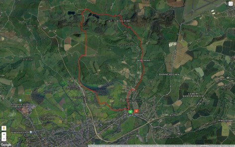
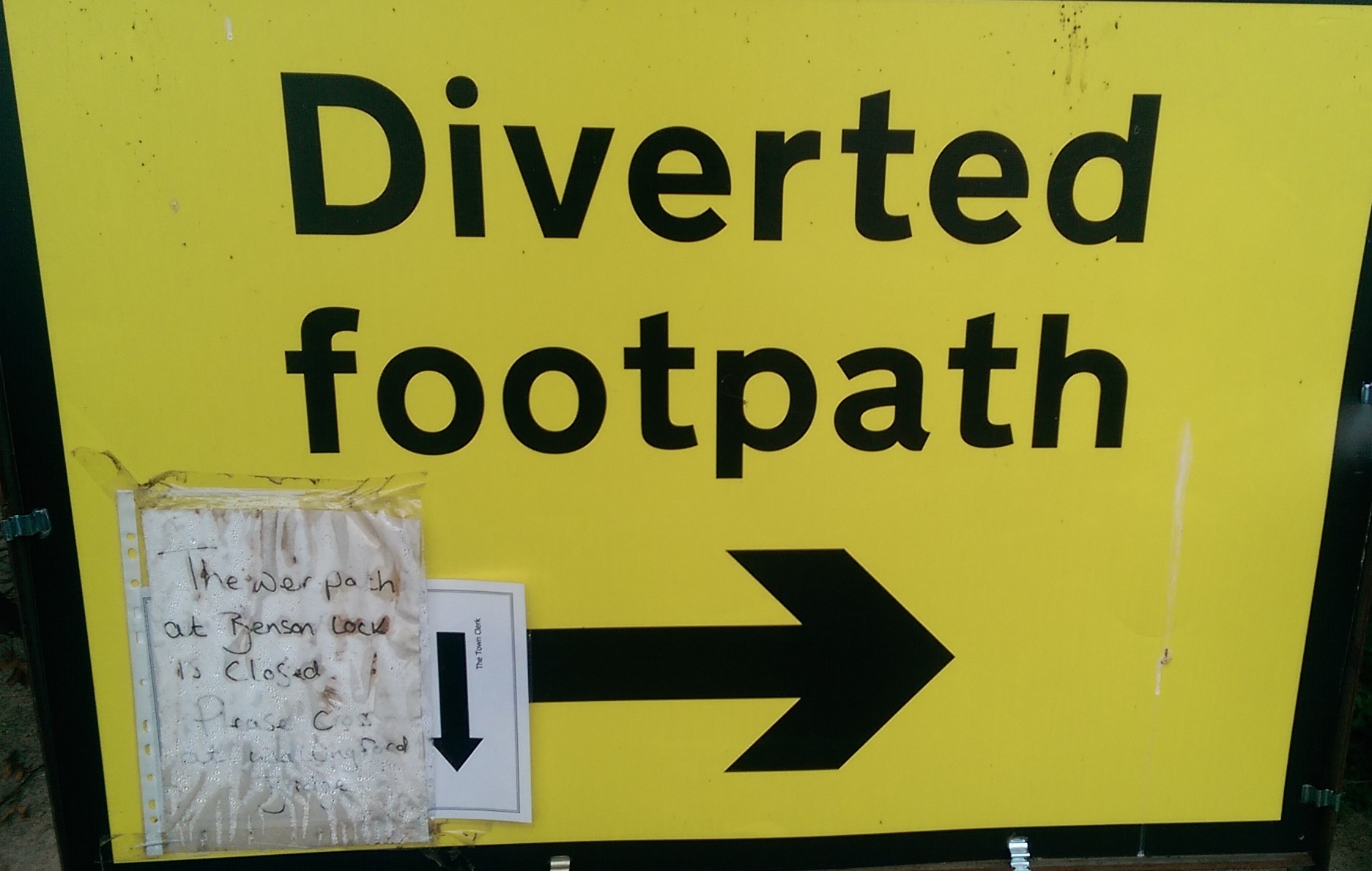
Annoyed. Really rather miffed, actually. You see, when the Highways Agency closes a road, they put great big signs across the carriageway informing you of the fact. They use cones and flashing lights to reinforce the message, so that there is no mistaking the fact that the road is, indeed, closed. However, when the Environment Agency closes a footpath, say for example the Thames Path, they will make a sign, but they will then tuck it away in a bin enclosure alongside said footpath, i.e.  not anywhere that someone walking said path is bound to see it. The sign will state “Diverted Footpath” and will have a bold black arrow on it – but the bold black arrow will point in the exact direction that the aforementioned walker was planning to walk anyway so even if he did spot the carefully hidden sign, why would he change his route? Well, I’ll tell you why – because the Environment Agency supplemented their sign (the one with the arrow pointing in the wrong direction) with a hand-written note on A4 paper which they put in a plastic bag and stuck to the sign. The note said “cross the bridge to the other side and follow the diversion”, and the plastic bag ensured that the note would be covered in rainwater and condensation so that you couldn’t read it unless your nose was six inches away. Now that really got my dander up. And you will see that this rather spoiled my day. Following this bulletin, there will be a strongly worded email to the Environment Agency. Grrrr…
IMAG0144 
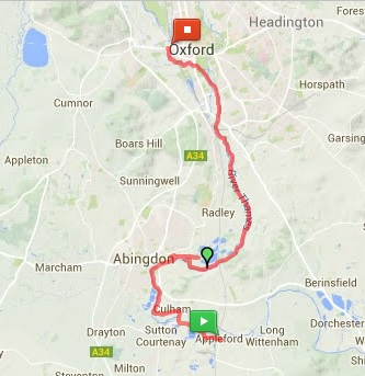
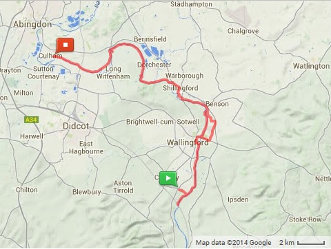
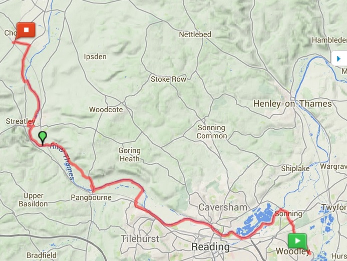
Continue reading S2S Leg11: Cholsey to Culham

S2S Leg 10: Sonning to Cholsey

10 Sonning CholseyThe only leg that starts from my front door! Not that I live on the riverside (except in my dreams), it still took me 45 minutes to get back to the river, but at least there was no public transport involved in getting started.

West of  Reading Bridge I came across a group of half a dozen elderly folk walking along the river. As I overtook them one gentleman said to me “how far are you going today?” and feeling a bit smug I replied “I’m going to Cholsey, should be about 20 miles or so”, he replied “Oh, we’re going to Cholsey as well!”. Whaat?! I’m gonna have to seriously up my game here… but then he added “but we’re doing most of it by train”. Oh thank God. But just imagine if I were to bump into them again, at Cholsey, at the end of a long day’s walking… What would be the chances of that?
Continue reading S2S Leg 10: Sonning to Cholsey

S2S Leg 9: Marlow to Sonning

9 - Marlow SonningI walked to the local station and travelling a couple of stops before changing trains, travelling a couple more stops, changing again and trundling along on the Marlow Donkey to, well, Marlow.

For much of the train journey I was accompanied by people wearing wellies, and day-glo makeup, and flowers in their hair. Festival-goers either heading to the site for a day’s fun, or heading back home for a shower after last night’s fun. And a very drunk man (at 9am. Not judging, just sayin’…) whom I told to get his feet off the seat so that I could sit down. He was slouched on a half-empty (half-full? Was he an optimistic drunk?) bottle of whisky. Had I realised how drunk he was I might have just sat somewhere else. Not for the fear of violence but the fear of vomit. But happily he managed to keep it down until I left the train at Maidenhead.
Continue reading S2S Leg 9: Marlow to Sonning